
1071 John Stark Hwy Newport, NH 03773
Property details
About 1071 John Stark Hwy
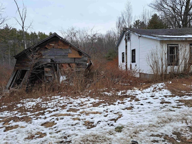
15 ACRES IN RURAL COMMERCIAL DISTRICT BETWEEN NEWPORT AND CLAREMONT. THERE IS AN ABANDONED HOUSE AND GARAGE ON THE PROPERTY WHICH BOTH NEED TO BE DEMOLISHED. BOTH ARE IN TARE DOWN CONDITION. DO NOT ENTER THE BUILDINGS WHICH ARE CONSIDERED UNSAFE. ALTHOUGH THERE IS AN OLD DUG WELL AND SEPTIC, THE SELLER HAS NO KNOWLEDGE OF EITHER. LOTS OF POSSIBILITIES FOR EITHER A BUILDING LOT FOR A RESIDENTIAL HOME TUCKED BACK IN FROM THE ROAD OR FOR A COMMERCIAL BUILDLING WITH WITH PLENTY OF ROOM FOR A LARGE BUILDING AND PLENTY OF PARKING. PROPERTY BEING SOLD AS IS , AS SEEN.
Highlights
Summary
- MLS Number: 5024870
- Office Name: Coldwell Banker Homes Unlimited
- Office Phone: (603) 542-2503
- Office Email: jranney15@gmail.com
- Listing Agent: Jan Ranney
 © Copyright 2025 PrimeMLS, Inc. All rights reserved. This information is deemed reliable, but not guaranteed. The data relating to real estate displayed on this site comes in part from the IDX Program of PrimeMLS. The information being provided is for consumers’ personal, non-commercial use and may not be used for any purpose other than to identify prospective properties consumers may be interested in purchasing.
Housing Market Reports are calculated by Rocket Homes Real Estate, LLC and based on information from the MLS.
Data displayed may be a portion of, and not a complete set of all listings published in the MLS.
Last updated on: 4/13/2025, 6:20:48 AM Eastern. If you have any questions regarding the accuracy of this data, please contact us at help@rockethomes.com.
Get an agent. Get a mortgage. Save big.¹
$159,900
1071 John Stark Hwy
Sell your home with Rocket and save even more!
Seller rebate
0.5% sale price²
Price information
Property sales
We're sorry, we currently don't have property sales data for this listing.
Tax history
| Year | Assessment | Property Tax |
|---|---|---|
| 2023 | $89,672 | $2,114 |
| 2022 | $95,548 | $1,997 |
| 2021 | $65,855 | $2,173 |
| 2020 | $65,881 | $2,181 |
| 2019 | $65,918 | $2,144 |
History based on county public records data.
Nearby schools
3
Disnard Elementary School
Public District KG-5
3.9 mi
•160 Hanover St
5
Bluff School
Public District KG-5
4.1 mi
•1 Summit Rd
1
Richards School
Public District PK-5
4.7 mi
•21 School St
School ratings are a score out of 10, where 10 is the highest and 1 is the lowest.
Neighborhood
The neighbors living near this home have an average income of $52,055. Residents of Newport, NH typically earn between $35k-100k each year. Residents typically live in married, no kids family. The most common level of education of people living in this area is high school diploma.
How much money do the neighbors make?
What level of education do the neighbors have?
What types of families live nearby?
Are the neighbors home owners or renters?
How old are people in this area?
What do the neighbors do for fun?
 Hunting
 NASCAR
 Figure Skating
Where do the neighbors shop?
 Academy Sports & Outdoors
 Bass Pro Shops
 Wal-Mart
Where do the neighbors go to eat?
 Jimmy Johns
 Hardee's
 Applebees
What do the neighbors drive?
 Chevrolet
 GMC
GMC Ram
Ram
What do the neighbors listen to?
 New Country
 Classic Country
 Oldies
Frequently asked questions
About 1071 John Stark Hwy
This home is located at 1071 John Stark Hwy in Newport, NH and zip code 03773. Features: 0 bathroom. It has been listed on Rocket Homes since December 18, 2024 and is currently priced at $159,900.
While more than 1 listings in Newport, NH in March 2025 were sold above asking price, there were more than 2 listings sold at asking price, and more than 2 were sold below. The number of listings in Newport, NH decreased by 34.6% between February and March 2025.