Property details
About Croom Airport Rd
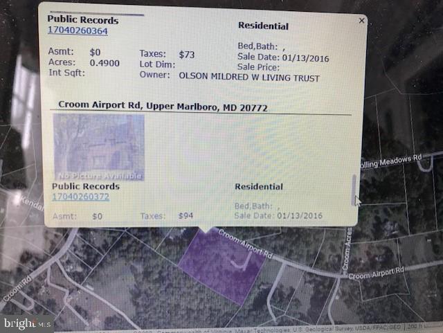
Two parcels of 1 acre and .49 acre on Croom Airport Road adjoin to form a site zoned Agricultural and with residential land use. Each parcel has its own tax ID. The one-acre parcel is in the southwesterly part of the lot 14 and the .49 acre parcel is in the central part of lot 14. Parcels totaling 1.49 acres are located BEHIND the homes and associated property at 14403 and 14405 and 14409 Croom Airport Road on undeveloped, wooded land.
Highlights
(ACTIVE)
Summary
- MLS Number: MDPG2085780
- MLS Name: BRIGHT
- Office Name: Long & Foster Real Estate, Inc.
- Office Phone: (301) 694-8000
- Listing Agent: Theresa T Michel
 Information Deemed Reliable But Not Guaranteed. The data relating to real estate for sale on this website appears in part through the BRIGHT Internet Data Exchange program, a voluntary cooperative exchange of property listing data between licensed real estate brokerage firms in which participates, and is provided by BRIGHT through a licensing agreement.
The information provided by this website is for the personal, non-commercial use of consumers and may not be used for any purpose other than to identify prospective properties consumers may be interested in purchasing. Some properties which appear for sale on this website may no longer be available because they are under contract, have sold or are no longer being offered for sale. Some real estate firms do not participate in IDX and their listings do not appear on this website. Some properties listed with participating firms do not appear on this website at the request of the seller. This home sale information is not to be construed as an appraisal and may not be used as such for any purpose.
BRIGHT MLS is the (or a) provider of this home sale information and has compiled content from various sources. Some properties represented may not have actually sold due to reporting errors. ©2025 BrightMLS. All rights reserved.
Data displayed may be a portion of, and not a complete set of all listings published in the MLS.
Last updated on: 2/7/2025, 4:20:50 AM Eastern. If you have any questions regarding the accuracy of this data, please contact us at help@rockethomes.com.
Get an agent. Get a mortgage. Save big.¹
$100,000
Croom Airport Rd
Sell your home with Rocket and save even more!
Seller rebate
0.5% sale price²
Price information
Property sales
We're sorry, we currently don't have property sales data for this listing.
Tax history
We're sorry, we currently don't have tax history data for this listing.
Nearby schools
3
Marlton Elementary School
Public District KG-5
3.5 mi
•8506 Old Colony Dr S
7
Mattaponi Elementary School
Public Magnet KG-5
4.2 mi
•11701 Duley Station Rd
2
Rosaryville Elementary School
Public District KG-5
4.9 mi
•9925 Rosaryville Rd
School ratings are a score out of 10, where 10 is the highest and 1 is the lowest.
Neighborhood
The neighbors living near this home have an average income of $110,842. The most common annual income of people living in Upper Marlboro, MD is between $100k-200k. Most families are married, no kids. Residents of this area typically have post secondary degree education.
How much money do the neighbors make?
What level of education do the neighbors have?
What types of families live nearby?
Are the neighbors home owners or renters?
How old are people in this area?
What do the neighbors do for fun?
 Hunting
 Figure Skating
 NASCAR
Where do the neighbors shop?
 Dillards
 Dick's Sporting Goods
 Dollar General
Where do the neighbors go to eat?
 Cracker Barrel
 Texas Roadhouse
 Applebees
What do the neighbors drive?
 Cadillac
 Subaru
 Ram
Ram
What do the neighbors listen to?
 News/Talk/Information
 New Country
 Classic Country
Frequently asked questions
About Croom Airport Rd
This home is located at Croom Airport Rd in Upper Marlboro, MD and zip code 20772 in the Patuxent Manor neighborhood. Features: 0 bathroom. It has been listed on Rocket Homes since August 4, 2023 and is currently priced at $100,000.
In January 2025 more than 19 listings in Upper Marlboro, MD were sold above the asking price. During the same period more than 20 listings were sold at asking price, while more than 10 were sold below. In January 2025 in Upper Marlboro, MD there were 5.9% more homes for sale than in December. In January 2025 median list price was $450,300 and the average listing age was 27 days.